magazine_ Article
Earth's swan song
What are thermokarst lakes and why soil warming should worry us even more than air warming
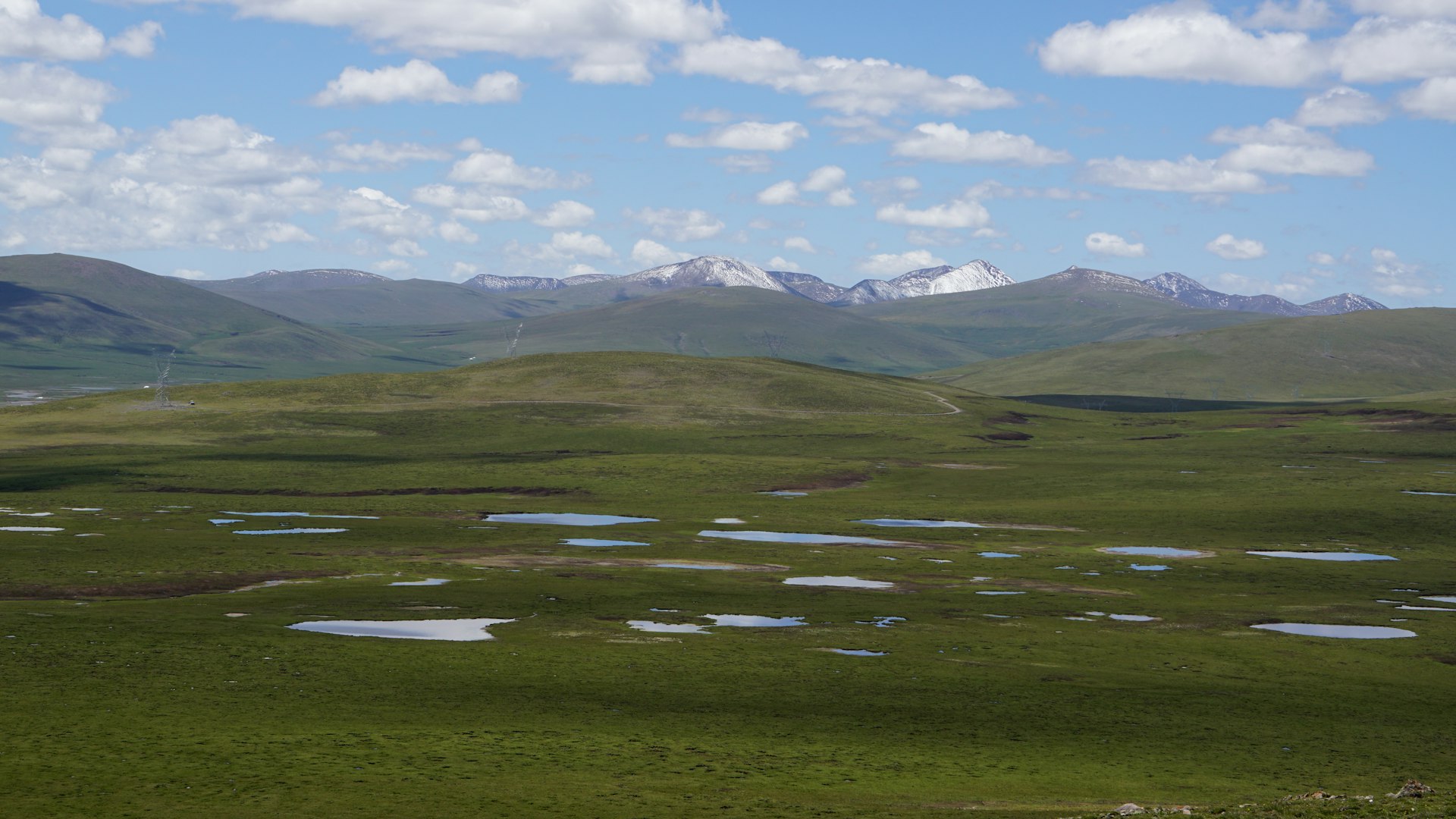
Thermokarst lakes on the Tibetan Plateau in China's Qinghai Province.
© null | Raul-David Șerban
What are thermokarst lakes? Why is it critical to monitor permafrost? And how do we monitor the temperature of Ground Surface Temperature (GST)? Geographer Raul Serban provides us with answers he’s gleaned from his research: from the Tibetan Plateau in China's Qinghai Province to the Alps. Spoiler alert: a forecasting model is being developed in the Mazia Valley that could have worldwide implications.
Ye'niugou village has been behind for at least 25 minutes when the pickup pulls up along Highway G214. Raul gets out, squeezes into his windbreaker, and walks slowly while the dry grass crunches under his boots. After a few steps, his breath is already labored. And even though Raul has been on the Tibetan plateau in China's Qinghai province for a few days now, the altitude still fatigues him. Ahead, the main pass of the Bayan Har Mountains-where one of the sources of the Yellow River is located-sits at around 4,800 m, and farther up rests the peak at an impressive 5,085 m. It may look close by eye, but one can easily imagine how tiring the ascent must be on foot. The landscape is enchanting: green expanses as far as the eye can see, dotted with glistening, icy lakes. However, Raul keeps his eyes on the ground: he is a soil researcher and it’s not a tourist excursion. He is here on a mission - to download data from one of 39 sites scattered across 150 square kilometers where sensors to measure soil temperature have been installed at a depth of about five centimeters.
"I like to walk here, get away from the passing trucks on the highway, and just listen to the sounds of nature," says Raul Serban, who holds a Ph.D. in periglacial geomorphology from Romania’s West University in Timisoara and an active research fellowship at Eurac Research. "The small bodies of water scattered around are called thermokarst lakes and although they are magnificent indeed, they are also highly alarming to me. In fact, they form when the permafrost thaws, which means that the rising temperatures due to climate change also affect the soil."
"The thermokarst lakes are magnificent, but they are also highly alarming to me. In fact, they form when the permafrost thaws, which means that the rising temperatures due to climate change also affect the soil."
Raul Serban
Raul Serban and his team collected data on the Tibetan Plateau between 2019 and 2020 and verified that the temperature of the upper soil layer varies between -4.7 and 2.3 °C, with consistent differences due to altitude and the presence or absence of vegetation. These temperatures sound low but they are not low enough. In itself, the fact that thermokarst lakes are forming is a not very good sign: it indicates that the permafrost has thawed and not reformed. But the situation could still get worse: if the permafrost continues to thaw deeper, water will drain underground and the lakes, with their water reserves, will literally be "swallowed" by the Earth.
In the area of the Tibetan Plateau studied by Raul Serban and his fellow researchers, the number of thermokarst lakes decreased by 40 percent between 1985 and 2015, and their surface area also shrank, by 25 percent. And therefore, since thermokarst lakes account for nearly half of all the water bodies in the region, a valuable source of water has been lost with them, irreparably disrupting both the hydrogeological and biological processes associated with these bodies of water.
Thermokarst lakes are like the swan song of an ecosystem, offering the best in terms of beauty and resources just before they disappear.
The ground surface temperature (GST)
The ground surface temperature (GST) is recorded between five and ten centimeters deep. It does not actually measure the permafrost itself but is a crucial indicator to better understand its thermal evolution, as well as changes in the so-called "active layer" of soil that thaws and refreezes on a seasonal basis as well as for understanding more about soil in general.
The risks
If air temperature is the best-known parameter for reporting climate change, soil temperature is perhaps the most dramatic.
Indeed, soil temperature is a valuable indicator of what is going on beneath us, and "soil is the memory of the past. The deeper you go, the more conditions from hundreds of years ago are revealed," explains Giacomo Bertoldi, an environmental engineer who has been studying hydrogeological cycles in the Alps for years at Eurac Research. "When climate change also registers in soil temperature, it means that these effects are profound, and that unless we address them, their consequences will be felt for a very long time."
Since the mid-1970s, permafrost temperature at depths of between 10 to 20 m has been increasing by 0.5 to 3 °C in most locations, although in certain places it has remained relatively stable. However, there are no known sites where the temperature of the permafrost is decreasing.
On the Tibetan Plateau in Qinghai Province, the concerns of the Chinese Academy of Sciences are real. Ground instability due to rising soil temperatures threatens engineering infrastructure, starting with the G214 highway itself, along which several sensors have in fact been placed for monitoring. The main fear is of landslides and the subsequent failure of the road’s load bearing supports.
"What's going on underground may not be visible, but that doesn't mean it doesn't cause critical situations, including here in the Alps," Giacomo Bertoldi continues. "The most glaring examples we already know about are rock detachments, which happen when two layers of soil come apart and the shallower one slides down." It can happen on an unfrequented peak, but it can also happen near infrastructure, above a population center or near where cable car pylons rest...
The risks don’t stop at hydrogeological ones either.
The role of the soil as a reservoir of carbon dioxide is not yet well understood, but for certain when permafrost thaws it releases methane and other greenhouse gases, and it also thaws organic material, including pathogens that may still be active -as an anthrax outbreak in Siberia demonstrated in 2016.
And if landscape, as well as elevation, influences soil temperature (where there is vegetation it is generally lower because vegetation protects against solar radiation), the reverse is also true:
soil temperature impacts the uses – especially agricultural ones which that soil could potentially be used for. So, keeping it monitored helps us to make more informed choices. Thawing permafrost also impacts water availability for those who live and work downstream: for example, in Tibet, if the seasonal river regime changes in the Yellow River headwaters area, hundreds of millions of people are affected.
From China to the Alps and back
Although at roughly the same latitude of about 45°, the plateau where the Yellow River originates in China and the Alps, particularly the area of the Mazia Valley, are certainly different environments in terms of elevation, temperature, and vegetation. However, right now, research that aspires to better monitor the temperature of the upper soil layer connects them.
"The most traditional method is permafrost drilling but it’s very expensive and does not allow an overview," explains Raul Serban. "On the Tibetan plateau, we employed a more innovative system which we ourselves had previously tested on the Carpathian Mountains and other worldwide alpine and cold regions, one that relies on sensors implanted underground that record temperature at regular intervals, every three hours." In the Mazia Valley, the researchers would like to take a further step by developing a soil temperature prediction model that relies on different sources: ground data, satellite images and hydrogeological models. "In this way we want to monitor large areas accurately, highlighting differences between different elevations and different soil types," comments Raul Serban.
The model being developed in the coming months in the Mazia Valley will be validated on the Tibetan plateau to test its reliability anywhere in the world.
 technical documentation
Scientific publications on thermokarst lakes in the Headwater Area of the Yellow River
The TEMPLINK Project is funded by the Autonomous Province of Bolzano’s Seal of Excellence Program.
